← Back to all countries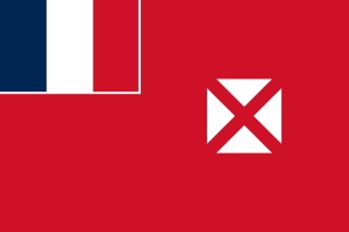
Wallis and Futuna
Territory of the Wallis and Futuna Islands
LOCATION
- Background
- Around 800 B.C., the first settlers arrived on the islands of Wallis and Futuna, which are a natural midpoint between Fiji and Samoa. Around A.D. 1500, Tongans invaded Wallis, and a chiefdom system resembling Tonga’s formal hierarchy developed on the island. Tongans attempted to settle Futuna but were repeatedly rebuffed. Samoans settled Futuna in the 1600s, and a slightly less centralized chiefdom system formed. Dutch explorers were the first Europeans to see the islands in 1616, followed intermittently by other Europeans, including British explorer Samuel WALLIS in 1767. French Catholic missionaries were the first Europeans to permanently settle Wallis and Futuna in 1837, and they converted most of the population of both islands by 1846. The missionaries and newly converted King LAVELUA of Uvea on Wallis asked France for a protectorate in 1842 following a local rebellion. France agreed, although the protectorate status would not be ratified until 1887. In 1888, King MUSULAMU of Alo and King TAMOLE of Sigave, both on Futuna, signed a treaty establishing a French protectorate; the Wallis and Futuna protectorate was integrated into the territory of New Caledonia the same year. France renegotiated the terms of the protectorate with the territory’s three kings in 1910, expanding French authority.Wallis and Futuna was the only French colony to side with the Vichy regime during World War II, until the arrival of Free French and US troops in 1942. In 1959, inhabitants of the islands voted to separate from New Caledonia, becoming a French overseas territory in 1961. Despite the split, a significant Wallisian and Futunan community still lives in New Caledonia. In 2003, Wallis and Futuna became a French overseas collectivity. The islands joined the Pacific Islands Forum as an associate member in 2018, two years after France’s other Pacific territories became full members of the organization.
- Location
- Oceania, islands in the South Pacific Ocean, about two-thirds of the way from Hawaii to New Zealand
- Geographic coordinates
- 13 18 S, 176 12 W
- Map references
- Oceania
- Area
- total: 142 sq km
land: 142 sq km
water: 0 sq km - Area - comparative
- 1.5 times the size of Washington, D.C.
- Land boundaries
- total: 0 km
- Coastline
- 129 km
- Maritime claims
- territorial sea: 12 nm
exclusive economic zone: 200 nm - Climate
- tropical; hot, rainy season (November to April); cool, dry season (May to October); rains 250-300 cm per year (80% humidity); average temperature 26.6 degrees Celsius
- Terrain
- volcanic origin; low hills
- Elevation
- highest point: Mont Singavi (on Futuna) 522 m
lowest point: Pacific Ocean 0 m - Natural resources
- NEGL
- Land use
- agricultural land: 42.3% (2023 est.)
agricultural land: arable land: arable land: 7% (2023 est.)
agricultural land: permanent crops: permanent crops: 35.2% (2023 est.)
agricultural land: permanent pasture: permanent pasture: 0% (2022 est.)
forest: 74.9% (2023 est.)
other: 0% (2023 est.) - Irrigated land
- 0.6 sq km (2022)
- Natural hazards
- cyclones; tsunamis
- Geography - note
- both island groups have fringing reefs; Wallis contains several prominent crater lakes
- Population
- total: 15,998 (2025 est.)
male: 8,217
female: 7,781 - Nationality
- noun: Wallisian(s), Futunan(s), or Wallis and Futuna Islanders
adjective: Wallisian, Futunan, or Wallis and Futuna Islander - Ethnic groups
- Polynesian
- Languages
- Wallisian (indigenous Polynesian language) 58.9%, Futunian 30.1%, French (official) 10.8%, other 0.2% (2003 est.)
- Religions
- Roman Catholic 99%, other 1%
- Age structure
- 0-14 years: 19.8% (male 1,643/female 1,511)
15-64 years: 67.5% (male 5,535/female 5,247)
65 years and over: 12.7% (2024 est.) (male 1,023/female 1,005) - Dependency ratios
- total dependency ratio: 48.7 (2025 est.)
youth dependency ratio: 29 (2025 est.)
elderly dependency ratio: 19.7 (2025 est.)
potential support ratio: 5.1 (2025 est.) - Median age
- total: 36.9 years (2025 est.)
male: 35.5 years
female: 37.3 years - Population growth rate
- 0.19% (2025 est.)
- Birth rate
- 11.63 births/1,000 population (2025 est.)
- Death rate
- 6.13 deaths/1,000 population (2025 est.)
- Net migration rate
- -3.56 migrant(s)/1,000 population (2025 est.)
- Urbanization
- urban population: 0% of total population (2023)
rate of urbanization: 0% annual rate of change (2020-25 est.) - Major urban areas - population
- 1,000 MATA-UTU (capital) (2018)
- Sex ratio
- at birth: 1.05 male(s)/female
0-14 years: 1.09 male(s)/female
15-64 years: 1.05 male(s)/female
65 years and over: 1.02 male(s)/female
total population: 1.06 male(s)/female (2024 est.) - Infant mortality rate
- total: 3.8 deaths/1,000 live births (2025 est.)
male: 3.8 deaths/1,000 live births
female: 3.9 deaths/1,000 live births - Life expectancy at birth
- total population: 81.1 years (2024 est.)
male: 78.2 years
female: 84.2 years - Total fertility rate
- 1.71 children born/woman (2025 est.)
- Gross reproduction rate
- 0.84 (2025 est.)
- Drinking water source
- improved: rural: rural: 99.3% of population (2022 est.)
improved: total: total: 99.3% of population (2022 est.)
unimproved: urban: urban: NA
unimproved: rural: rural: 0.7% of population (2022 est.)
unimproved: total: total: 0.7% of population (2022 est.) - Sanitation facility access
- improved: rural: rural: 94.2% of population (2022 est.)
improved: total: total: 94.2% of population (2022 est.)
unimproved: rural: rural: 5.8% of population (2022 est.)
unimproved: total: total: 5.8% of population (2022 est.) - Currently married women (ages 15-49)
- 57.2% (2018 est.)
- Literacy
- total population: 99.8% (2023 est.)
male: 99.9% (2023 est.)
female: 100% (2023 est.)
- Environmental issues
- deforestation (only small portions of the original forests remain) due to wood as the main fuel source; soil erosion; lack of natural freshwater resources; lack of soil fertility on the islands of Uvea and Futuna
- Climate
- tropical; hot, rainy season (November to April); cool, dry season (May to October); rains 250-300 cm per year (80% humidity); average temperature 26.6 degrees Celsius
- Land use
- agricultural land: 42.3% (2023 est.)
agricultural land: arable land: arable land: 7% (2023 est.)
agricultural land: permanent crops: permanent crops: 35.2% (2023 est.)
agricultural land: permanent pasture: permanent pasture: 0% (2022 est.)
forest: 74.9% (2023 est.)
other: 0% (2023 est.) - Urbanization
- urban population: 0% of total population (2023)
rate of urbanization: 0% annual rate of change (2020-25 est.)
- Country name
- conventional long form: Territory of the Wallis and Futuna Islands
conventional short form: Wallis and Futuna
local long form: Territoire des Iles Wallis et Futuna
local short form: Wallis et Futuna
former: Hoorn Islands is the former name of the Futuna Islands
etymology: Wallis Island is named after British Captain Samuel WALLIS, who visited in 1767; Futuna is a local name, and the meaning is unclear - Government type
- parliamentary democracy (Territorial Assembly); overseas collectivity of France
- Dependency status
- overseas collectivity of France
- Capital
- name: Mata-Utu (on Ile Uvea)
geographic coordinates: 13 57 S, 171 56 W
time difference: UTC+12 (17 hours ahead of Washington, DC, during Standard Time) - Administrative divisions
- 3 administrative precincts (circonscriptions, singular - circonscription) Alo, Sigave, Uvea
- Legal system
- French civil law
- Constitution
- history: 4 October 1958 (French Constitution)
amendment process: French constitution amendment procedures apply - Citizenship
- see France
- Suffrage
- 18 years of age; universal
- Executive branch
- chief of state: President Emmanuel MACRON (since 14 May 2017); represented by Administrator Superior Jean-François de MANHEULLE (since 17 November 2025)
head of government: President of the Territorial Assembly Munipoese MULI'AKA'AKA (since 20 March 2022)
cabinet: Council of the Territory appointed by the administrator superior on the advice of the Territorial Assembly
election/appointment process: French president elected by absolute-majority popular vote in 2 rounds, if needed, for a 5-year term (eligible for a second term); administrator superior appointed by the French president on the advice of the French Ministry of the Interior; the presidents of the Territorial Government and the Territorial Assembly elected by assembly members - Legislative branch
- legislature name: Territorial Assembly (Assemblée territoriale)
legislative structure: unicameral
number of seats: 20 (directly elected)
electoral system: proportional representation
scope of elections: full renewal
term in office: 5 years
most recent election date: 3/20/2022
parties elected and seats per party: Ofa mo'oni ki tou fenua (2); Mauli fetokoniaki (2); 1 seat each from 16 other lists - Judicial branch
- highest court(s): Court of Assizes or Cour d'Assizes (consists of 1 judge; court hears primarily serious criminal cases)
judge selection and term of office: NA
subordinate courts: courts of first instance; labor court - Political parties
- Left Radical Party or PRG (formerly Radical Socialist Party or PRS and the Left Radical Movement or MRG)Lua Kae Tahi (Giscardians)Rally for Wallis and Futuna-The Republicans (Rassemblement pour Wallis and Futuna) or RPWF-LR Socialist Party or PSTaumu'a Lelei Union Pour la Democratie Francaise or UDF
- Diplomatic representation in the US
- none (overseas territory of France)
- Diplomatic representation from the US
- none (overseas collectivity of France)
- International organization participation
- PIF (observer), SPC, UPU
- Independence
- none (overseas collectivity of France)
- National holiday
- Fête de la Fédération, 14 July (1790)
- Flag
- description: unofficial local flag has a red field with four white isosceles triangles in the middle; the apexes of the triangles are oriented inward and at right angles to each other; a small flag of France, outlined in white on two sides, is in the upper-left cornermeaning: the triangles represent the three native kings of the islands and the French administratorhistory: the design is derived from a red flag with a white cross that French missionaries introduced in the 19th century
- National symbol(s)
- red saltire (Saint Andrew's Cross) on a white square on a red field
- National color(s)
- red, white
- National anthem(s)
- title: "La Marseillaise" (The Song of Marseille)
lyrics/music: Claude-Joseph ROUGET de Lisle
history: official anthem, as a French territory
- Economic overview
- lower-middle-income, agrarian French dependency economy; heavily reliant on French subsidies; licenses fishing rights to Japan and South Korea; major remittances from New Caledonia; aging workforce; import-dependent; deforestation-fueled fragility
- Agricultural products
- coconuts, breadfruit, yams, taro, bananas; pigs, goats; fish
- Industries
- copra, handicrafts, fishing, lumber
- Budget
- revenues: $32.54 million (2015 est.)
expenditures: $34.18 million (2015 est.) - Exports - partners
- Denmark 35%, Sweden 14%, Netherlands 14%, Pakistan 9%, Poland 7% (2023)
- Exports - commodities
- seats (2023)
- Imports - partners
- Fiji 35%, France 32%, NZ 11%, Australia 6%, China 4% (2023)
- Imports - commodities
- refined petroleum, prepared meat, poultry, iron pipe fittings, animal food (2023)
- Exchange rates
- Currency: Comptoirs Francais du Pacifique francs (XPF) per US dollar -
Exchange rates 2024: 110.31 (2024 est.)
Exchange rates 2023: 110.347 (2023 est.)
Exchange rates 2022: 113.474 (2022 est.)
Exchange rates 2021: 100.88 (2021 est.)
Exchange rates 2020: 104.711 (2020 est.)
- Telephones - fixed lines
- total subscriptions: 3,000 (2021 est.)
subscriptions per 100 inhabitants: 26 (2021 est.) - Telephones - mobile cellular
- total subscriptions: 12,200 (2023)
subscriptions per 100 inhabitants: 107 (2023) - Broadcast media
- publicly owned French Overseas Network (RFO), which broadcasts to France's overseas departments, collectivities, and territories, is carried on the RFO Wallis and Fortuna TV and radio stations (2019)
- Internet country code
- .wf
- Internet users
- percent of population: 45.8% (2021 est.)
- Airports
- 2 (2025)
- Merchant marine
- total: 1 (2023)
by type: general cargo 1 - Ports
- total ports: 1 (2024)
large: 0
medium: 0
small: 0
very small: 1
ports with oil terminals: 0
key ports: Mata-Utu
- Military - note
- defense is the responsibility of France